NATURAL HAZARDS
Extreme natural events are a recurring feature in many parts of the world. They are mostly weather-related and include droughts and floods, severe tropical cyclones, and heatwaves and bushfires. These events become hazards when they cause material damage to infrastructure, production and environmental resources, and/or the injury or death of people. Geographers investigate a range of hazard related issues including:
- The increased severity and frequency of drought as a result of climate change and the effect this has on the capacity of rural communities to adapt to generally dryer conditions.
- The resilience of farmers in the face of drought, and vital role in local towns play in providing social support to rural communities.
- The effects of flooding on river’s physical characteristics and how these affect the flooding events. Specific examples include the study of riverbank erosion over time, the identification of the major inundation surfaces and their average flood recurrence interval, modelling the effects of raising levee heights and identifying priority areas for restoring river-based vegetation that can reduce the severity of flooding.
- The vulnerability of environments to tropical cyclone damage. Specific examples include the resilience of intact tropical rainforests compared to remnant forests.
- Strategies for reducing hazard impacts including risk assessment, planning interventions, disaster resilience and storm and bushfire related building codes.
- Bushfire management.
- Mapping the vulnerability of communities to heatwaves and the development of mitigation strategies.
- The role of communities in disaster management.
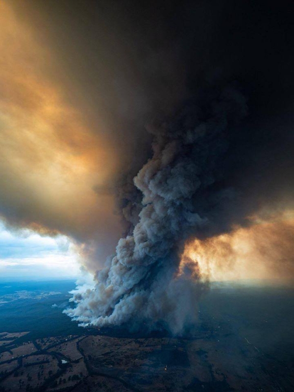
In early 2020 large areas of Eastern Australia were devastated by out of control bushfires driven by prolonged drought, at least in part a consequence of Australia’s warming climate (Source: ABC)
Relevant careers include climate change assessment and planning; climatology and meteorology; coastal, marine and hydrographic analysis; community development, and education; environmental and social impact assessment; environmental monitoring and management; environmental science; geographic information systems (GIS); geomorphology; hazard assessment, mitigation and disaster management; public policy, public safety, defence and natural security; remote sensing and research.


Leave A Comment